Whether you’ve been a supporter of the ECA for years, or are just learning about our work, the ECA is hearing the needs of our community and evolving to serve you better.
Evolving the ECA
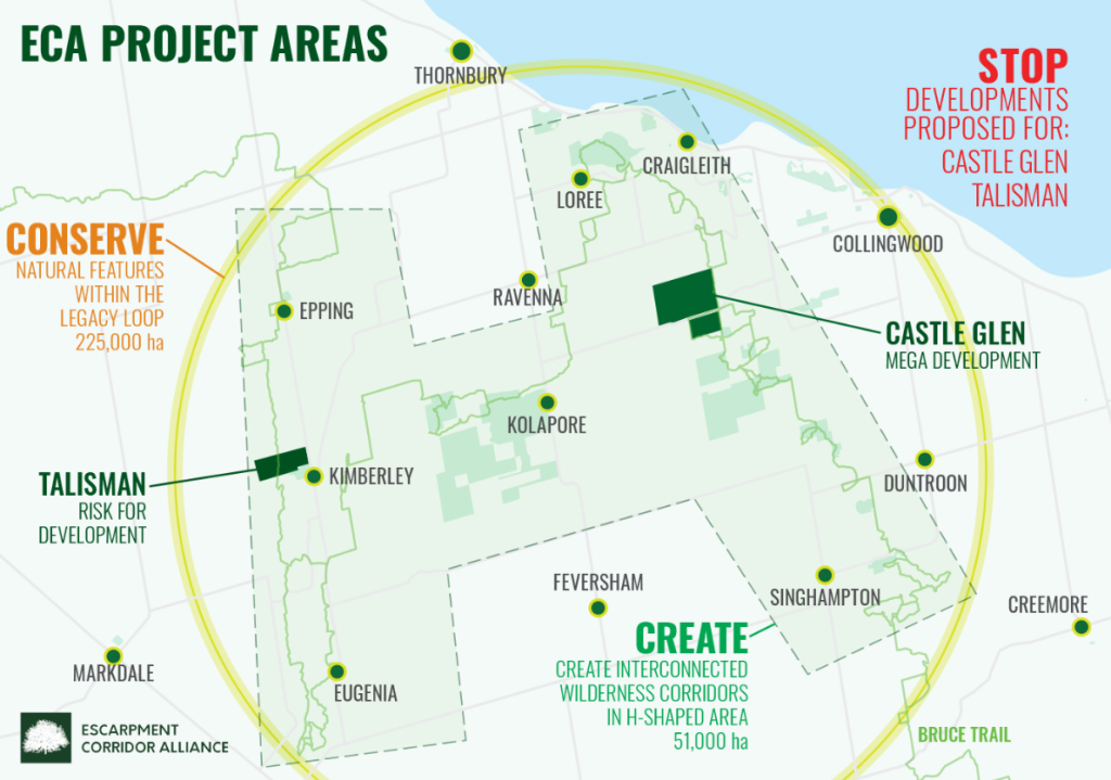
The ECA is a charity deeply rooting in community-led conservation – our organization is supported and run by community members. Like many environmental charities, we began as a small handful of concerned people, passionate about the environment. Two massive development projects threatened our community and the environment that we loved. Let’s clarify – we are not ANTI-development. Instead we are PRO-appropriately scaled and located development (learn more about these “Hot Spot” projects here: Save the Castle Glen Forest | Escarpment Corridor Alliance and Vision Talisman Project | Escarpment Corridor Alliance).
As we dove into learning about the local environmental impacts of these development projects, we started to consider the landscape-scale ecological implications and really started to get worried. We learned about habitat fragmentation in these rural communities, the impact to water quality, how wildlife movement would be altered, and about unsustainable growth. A vision of a more protected, more connected South Georgian Bay began to emerge, shaping the original “H” map..
Fast Forward: Guided by the Science
Ecological resilience and riparian areas became regular additions to our vocabulary as we learned about connectivity along waterways and between protected spaces. So, in 2024, the ECA commissioned a geospatial analysis. The goal was for a science-first understanding on the most Important Areas for Biodiversity (green blobs below) and how wildlife might move between them (teal connector lines). These areas are already offering essential habitat for native species and many have been provincially recognized, but they are not protected.

This map is both our inspiration and our starting place. This is our baseline. Without direct action to preserve these areas and restore the connections between them, these essential habitats will continue to decline, and the wildlife that call these places home will be left vulnerable and at risk.
The ECA’s corridor identification project was supported by the Greenbelt Foundation and the RBC Tech for Nature Grant. This project identified areas across South Georgian Bay that are already offering important functional habitats and ecosystem services that benefit both nature and people. By connecting these spaces in an ecological corridor, we can improve outcomes – for nature, for people, for good.

But the science is only the first step. In order to fully understand this Region, we must include the voices of those who have stewarded this land since time immemorial and who know it best. Learn more about the ECA’s Indigenous Relations work. In this landscape dominated by private landholders, we must also incorporate the participation of our community. By braiding together the science, Indigenous Knowledge and community participation, the ECA’s Corridor Program is deeply rooted for the future.
Importance of Watersheds in our Work
The ECA determined our Area of Influence to include these watersheds: Bighead River, Eugenia Lake & Beaver River, Mad River, Pine River and the South Georgian Bay Coastline between Meaford and Brocks Beach. Connecting the land and the water, this expansive region, spanning more than 200,000 hectares, is where we work. We prioritize projects that preserve and protect the known Important Areas for Biodiversity, seeing Areas of Opportunity as being within approximately 1 km, to support long-term ecological resilience and connectivity.

Stay tuned! The ECA is just getting started….
We are planning initiatives across our Area of Influence for 2026, including supporting sustainability in agriculturally dominated regions for benefits to food producers and a wetlands initiative to improve resilience to the impacts of climate change.


